Jyuyojiko Setsumeisho for a Single-Family Home: the Outline of Restrictions under the City Planning Law, Building Standards Law, and Other Laws and Regulations 2 (1) (2)2. The Outline of Restrictions under the City Planning Law, Building Standards Law, and Other Laws and Regulations (1) Restrictions under the City Planning Law 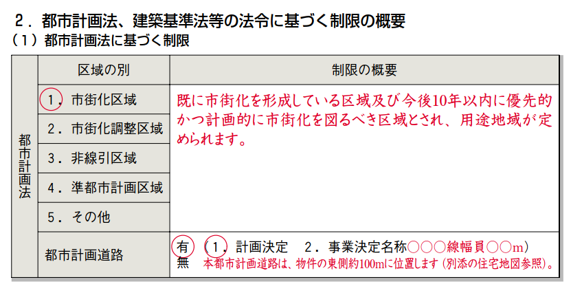 In this section, the outline of restrictions under the City Planning Law is disclosed. This section defines which of the following areas the property is located under the City Planning Law: 1. Urbanization Promotion Area (市街化区域) 2. Urbanization Control Area (市街化調整区域) 3. Undefined Area (非線引き区域) 4. Quasi-urban Planning Area (準都市計画区域) 5. Other (その他) In the above sample, 1.市街化区域 is circled in red, meaning that the property is located in an urbanization promotion area. The definition of the area is on the right column: it is defined as an area where urbanization is already underway and an area where urbanization should be prioritized and planned within the next 10 years. The information on urban planning roads (都市計画道路) is also disclosed in this section. In the above sample, 有 is circled in red in the lower column, indicating that there is a construction plan for an urban road. (1. Plan: This urban planning road is located approximately 100 meters to the east of the property. 2. Project name: OOOLine Width OOm) (See the attached housing map.) Note: As a general rule, no building can be constructed on land in an urbanization control area. (2) Restrictions under the Building Standards Law 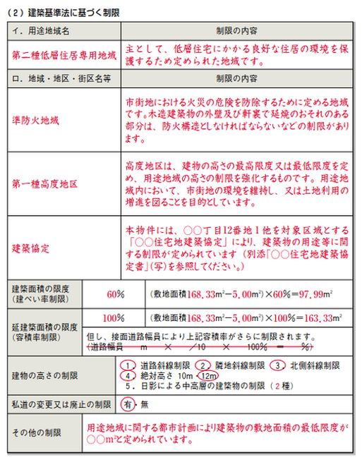 イ. 用途地域名:A Zoning Area
Zoning areas refer to areas divided into 13 areas according to use in order to form a planned urban area. In the above sample, the zoning area is 第二種低層住宅専用地域 (Category II medium-to-high-rise exclusive residential area) with the outline of the restriction on the area on the left column. ロ. 地域・地区・街区名等:Area, District, Town, etc. On the left side in (ロ)in the above sample are written 準防火地域 (Quasi-fire Prevention area), 第一種高度地区 (Category I high altitude district), and 建築協定(Building agreement), with the outline of the restrictions on the left columns. 建ぺい率の限度(建ぺい率の制限):Building-to-land ratio limits (Building-to-land ratio restrictions) In the above sample, 60 % (Land Area 168.33㎡ ー 5.00㎡) X 60% = 97.99㎡ 延建築面積の限度(容積率制限): Limit on the Total Building Area (Floor-area-ratio Limit) 100% (Land Area 168.33㎡ ー 5.00㎡) X 100% = 163.33㎡ *However, the above floor-area ratio will be further restricted depending on the width of the road that the property faces. (Road width m X /10 X 100% = %) In the above sample, this line is crossed out as it is non-applicable to this property. 建物の高さの制限: Building Height Restrictions 1. Setback regulation from road width 2. Neighboring diagonal line restriction 3. North side slant line regulation 4. Absolute height 10m / 12m 5. Restrictions on medium and high-rise buildings due to shading (Category 2) 私道の変更または廃止の制限: Restrictions on Alteration or Elimination of Private Roads Yes / No その他の制限: Other Restrictions ex) The minimum land area for a building is set at OO㎡ according to the city planning regarding the zoning area. *In principle, no building can be constructed on land in an area with a minimum land area limit unless the land area is greater than the minimum area limit. Note: Check carefully to see if you can build the building you want and what building restrictions are in place. The width of the front road may further restrict the floor area ratio. Comments are closed.
|
AuthorArrows International Realty Corp. Archives
June 2023
Categories
All
|
 RSS Feed