|
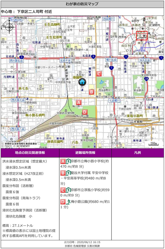
When brokering real estate for leasing or sale, real estate agents always confirm the disaster information about the location of the property. This is stipulated by the Building Lots and Buildings Transaction Business Law, and it is necessary to present the disaster information on the location of the building to the lessee/buyer. Kyoto Prefecture has a dedicated multi-hazard information provision system and we can find out more at this site. Kyoto Prefecture Multi-Hazard Information Providing System http://multi-hazard-map.pref.kyoto.jp/top/top.asp Here you can research floods, earthquakes and tsunamis, landslides, and disaster prevention information. Flooding can be surveyed for inundation due to floods, inundation areas such as house collapses, rainwater runoff, and storm surge, as well as inundation areas due to reservoir failures. In the case of Kyoto, the Kamo and Katsura rivers may be flooded, and approximate locations in the city are within the scope of the flooding. In addition, the earthquake and tsunami information can be used to investigate the assumed maximum seismic intensity of the earthquake and the Nankai megathrust earthquake. Japan is an earthquake-prone country, with a certain number of earthquakes occurring every year. There have been 25 earthquakes of intensity 1 or higher in Kyoto in the past year. Therefore, earthquakes are a very common occurrence when living in Japan. For sediment disaster information, it is possible to survey the sediment disaster caution area and the sediment disaster special caution area. Kyoto City is surrounded by mountains, and the area near the mountains is roughly within the sediment disaster warning area. This is also a known fact that Kyoto is surrounded by nature. For disaster prevention information, you can also check the Fukui nuclear power plant, evacuation site, and AED installation site. In the case of a real estate transaction, the following materials will be attached to provide disaster prevention information and evacuation site information at the location. Flood inundation expected area (estimated maximum) Inundation depth less than 0.5m
Inundation expected area: Inundation depth less than 0.5m Seismic intensity distribution map (Active fault) Seismic intensity upper 6 on the Japanese scale of seven Seismic intensity distribution map (Nankai Trough), seismic intensity of lower 6 on the Japanese scale of seven Liquefaction risk prediction map (active fault) Liquefaction risk is small 27.1 meters above sea level Evacuation site information This is also available to the general public, so please check the land you are interested in. |
Details
AuthorArrows International Realty Corp. Archives
June 2023
Categories
All
|

 RSS Feed